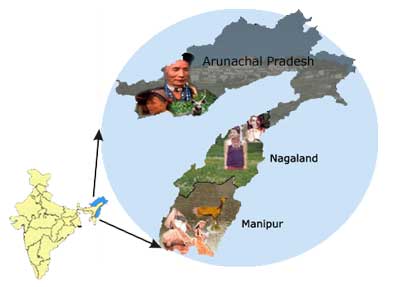
Profile of NE II Telecom Circle
The North East-II Telecom Circle, with headquarters at Dimapur, was carved out of the erstwhile composite NE Telecom circle on 21st January 2001. The jurisdiction of the NE-II Telecom Circle is co-terminus with the combined territorial boundaries of the far-east three of the seven sister states in the N. E. Region viz. Arunachal Pradesh, Manipur and Nagaland. The circle is responsible for the provision, operation, maintenance and development of the Telecommunication Services and facilities in these three states serving a population of 5254792 spread over an area of 1,22,649 Sq.Kms.
Most parts of the circle are of hilly terrain criss-crossed by innumerable rivers and rivulets covered with lush green forests. Arunachal Pradesh, the "the land of the Dawn-lit Mountains" is India's land of rising sun. It is the country's remotest state and is signified by charming and innocent tribals with glorious heritage of art and crafts, enchanting flock songs, natural unspoilt beauty, rare orchids and exotic animals such as Yak and Mithun. It is a place of fascination and enthrallment for the nature lover. Manipur, variously described as "Land of Gems", "Jewel of India", "A Little Paradise" and as "Kashmir of Eastern India" is a land of ridges and valleys of mountain chain pronounced with natural scenery, salubrious climate, rich cultural harmony, martial arts, sprinkled. Nagaland, the land of music, dance, pomp and pageantry, is referred to as the "Switzerland of the East" and is located in the extreme northeastern part of the country with variegated hilly terrains, border by Myanmar in the east. The people of Nagaland belong to the Indo Mongoloid stock, blessed with sturdy formidable disposition under the nature's abundant gifts. The colourful and intricately designed costumes, jewellery and beads that they adorn, distinguish them from the others.
The entire North East-II area, in general, is far-flung and away from the rest of the country. The population is well spread, living in small groups in villages, with the exception of cities and towns, where the concentration is more. The traditional ceremonial attire of each tribe is in itself an awe-inspiring sight to behold.
The entire North East - II area is strategically important having very large lengths of International border with China, Bhutan and Myanmar. The area is subjected to rainfall for all most 8 months in a year and is prone to landslides and flood, making large parts inaccessible during this period. Such an environment throws up innumerable challenges for the development, provision, operation and maintenance of Telecom services.
The Circle has its Headquarter at Dimapur and is headed by a Chief General Manager. There are three (3) Secondary Switching Areas (SSA) and each of the SSA are headed by General Manager with their Head Quarters located at Dimapur (Nagaland SSA), Imphal (Manipur SSA) and Itanagar (Arunachal Pradesh SSA). The operation, maintenance and developmental activities in their respective SSAs are looked after by these General Managers Telecom located in each of the three states.
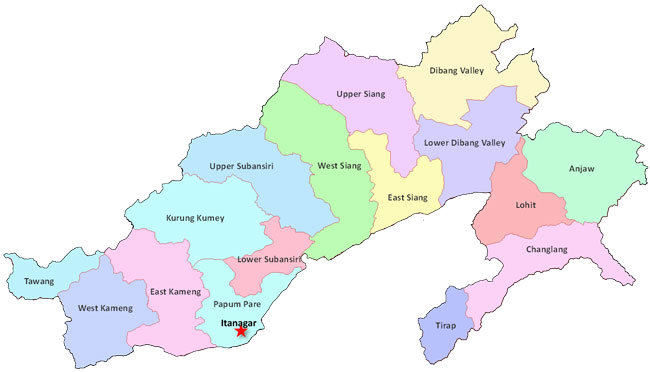
Arunachal Pradesh SSA
Arunachal Pradesh, a land of Dawn-lit mountains is a thinly populated hilly track on the Eastern most part of India, surrounded on the three sides by international border with Bhutan to the west, China to the North and Myanmar to the East and Assam to the South.
Arunachal Pradesh is entirely mountainous except for thin strip of the flat land, most of which is adjoined to Assam. Evergreen forests cover more than 60 % of area with its numerous turbulent streams, roaring rivers, deep gorges, lofty mountains, snow-clad shining peaks, hundred and thousand species of flora and fauna. Its endless variation of scenic beauty is the first to greet the sunrise in the country.
Arunachal Pradesh is criss-crossed by innumerable mighty rivers and rivulets. The climate is hot and humid at the lower altitude and in the valley covered by swampy dense forests particularly in the eastern region, while it becomes exceedingly cold in the altitude. The rainfall is amongst the heaviest in the country.
The people of Arunachal Pradesh are Mongoloid stock with glorious heritage of arts and crafts, enchanting folk songs and are simple, friendly and hospitable people. There are 26 Tribes in Arunachal Pradesh. The telecommunication activities in the State are controlled by General Manager Telecom and his office is located at Itanagar.
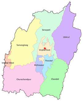
Manipur SSA
Manipur literally meaning "A jeweled land" nestle deep within a lush green corner of North East India. It seems much like an exquisite work of art executed by superb hands of Nature and is indeed a state of exquisite natural beauty and splendors, the beauty of which once inspired Mrs. St. Clair Grimwood described it as "A Pretty Place more beautiful than many show places of the world" Late Pandit Jawaharlal Nehru paid a fitting tribute by describing it as "Jewel of India".
Surrounded by blue hills with an oval shaped valley at the centre, rich in art and tradition and surcharged with nature's pristine glory. Manipur lies on a melting pot of culture. It is birth place of Polo. This is the place where Rajashree Bhagyachandra created the famous Ras Lila, the classical dance of Manipur, out of his enchanting dream by the grace of Lord Krishna.
The important tourist centre in the state is Imphal, the capital and centre of all commercial and cultural activities. Adorned with two war cemeteries by the Commonwealth war graves commission, Govindaji temple, women bazaar etc., besides, the Vishnu temples at Bishunpur built in 1467 AD, the Loktak lake, the biggest fresh water lake in eastern India, Keibul Lamjao, the only floating National Park in the world. The orchid yard at Khongampat, etc. are also quite attractive.
Manipur is bounded by Nagaland in the north, Mizoram in the south, Upper Burma in the east and Cachar district of Assam in the west. The Telecommunications facilities in the State of Manipur are controlled by General Manger Telecom. District head quarter at Imphal.
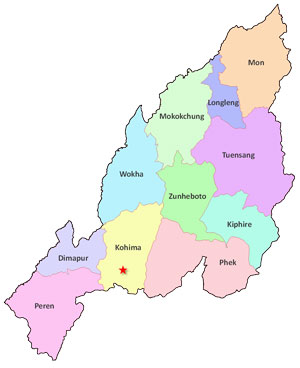
Nagaland SSA
The State of Nagaland is a narrow strip mountainous territory between the Brahmaputra valley of Assam and Myanmar (Burma). On the East it shares India's international boundary with Myanmar. On all the other sides it is bounded by Indian territory Manipur on the South, Assam on the West and North and Arunachal Pradesh on the North East.
Saramati, the highest peak is 3841 m high and Kohima, the capital is 1444.12 m above the sea level. The main rivers that flow through the state are Dhansiri, Doyang, Dikhu and Jhanji. The population of Nagaland is entirely tribal. This remote hilly area is covered with luxuriant vegetation, the climate is cool and bracing, the people are friendly and hospitable.
Nagaland is a land of folklore passed down the generations through word of mouth. The music is an integral part of life; folk songs eulogising ancestors, the brave deeds of warriors and traditional heroes; poetic love songs immortalising ancient tragic love stories; Gospel songs that touch your soul (should you have a religious bend of mind) or the modern tunes rendered exquisitely to set your feet a-tapping.
Each of the 16 odd tribes and sub-tribes that dwell in this exotic hill State can easily be distinguished by the colourful and intricately designed costumes, jewellery and beads that they adorn. The traditional ceremonial attire of each tribe is in itself, an awe inspiring sight to behold; the multicoloured spears and daos decorated with dyed goats hair, the headgear made of finely woven bamboo interlaced with orchid stems, adorned with boar's teeth and hornbill's feathers, elephant tusk armlets. In days of yore every warrior had to earn each of these items through acts of valour, to wear them.
In season the landscape is a riot of colour - wild flowers, thick forests, huge trees, tall grass, a wide variety of wild animals and brilliantly coloured birds. Tourist attractions include cemetery in Kohima, historic ruins of Kachari Kingdom, Dimapur and Dzukou Valley.